Considerations on The Viking Sun Compass
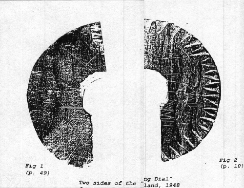 Table OF Contents Assumptions on Tenth Century Norse Navigation 3 Determining North.......................................5 By Angular Distance..............................5 By Using a Gnomon................................5 Navigating............................................8 Compensating for Sun's Angular Dlstance Change......10 Navigating East or West........................10 Navigating Directions Other than East or West..10 Determining Location by Gnomon Shadows..............13 Considerations on the Scratches ....................13 Addenda ............................................16 Effects of the Gulf Stream.....................16 Some Mathematics...............................16 Lengths of Gnomon Shadows......................18 Carving a Sun Compass..........................18 Conclusions.........................................18 Sources ............................................:20
By Ralph E. Robinson Edited by Victor Biagotti And Mead Stapler With technical help from Jon Bell and Joey Lopez. HTML code by Peter Sjolander.
Rerob1@aol.com
Comments on The Viking Sun CompassMuch controversy exists about whether or not a "Sun Compass" was a reality and if it were, how valuable was it to Norse seamen during the three hundred years from the 10th through 13th centuries. (The Norse may have had a magnetic compass in the 14th century.)
During the latter part of the 15th century, after four hundred years of being told as stories, various people compiled the Viking tales into books, collectively known as the "Norse Sagas." Three of the "Sagas" give similar accounts about the discovery of Vinland somewhere west of Greenland.
The Sagas also make unrevealing and curious references to a navigational aid called a "bearing dial."
After discovering part of a hockey-puck sized disk in a 1948 Greenland archaeological dig, "bearing-dial" speculation flared. The piece of "bearing dial," as it was called, is crudely carved and has a center hole too large for an accurate gnomon. (Fig. 1). Both of its surfaces have scratches and one surface has notched edges The incident is reminiscent of Sherlock Holmes' admonition: "When you have eliminated all that is possible, whatever is left, no matter how improbable, must be the truth." Thus, the Greenland disk was pronounced "bearing dial," because no other use can be ascribed to it. (See Figures 1,2,3)
This treatise will show that with knowledge of the time and using uncomplicated arithmetic, such a disk could have been made easily, that it would be useful as a directional compass, and it would provide a reasonably good way to infer a position at sea, although not in terms of longitude and latitude. The Greenland find was, in fact, a bearing dial oriented to 60 North Latitude and the best part of the year to sail. Note: We must always keep in mind that the Vikings had raided Europe taking not only loot, but slaves. Many slaves could have been unusually knowledgeable in mathematics.For over three thousand years before the age of Vikings, daily paths of the sun and moon were known. The Vikings would have known those paths. Furthermore, by the ninth century, with long experience of using their exquisite boats, the Norse were intimately familiar with their oceanic horizons and the "dome" of their oceanic skies. According to Howard LaFay, ". .. Odi Helgason [of Iceland]. . . . .in middle of the 12th century. . . worked out a table giving positions of rising sun from winter to summer solstice. . . also of sun . . .at noon at fortnightly intervals using sun diameters. . . as a measuring scale." p.203
Speculations that Norse navigators steered by the north star are exaggerated. While they were brave sailors, they were not stupid. In winter, (see Trychare p.14) when nights are long and the north star most visible, sailing in an open boat was uncomfortable and a snow or ice storm could soon build up enough weight to swamp it. In those high latitudes, with long summer days and long hours of twilight, the north star would be visible a short time in each twenty-four hours--plenty of time to deviate far from course. The sun and moon (and sometimes Venus), however, would have been useful. This treatise assumes that long voyages were planned between May first and mid August.
The Greenland "bearing dial" is not an example of Norse carving excellence. Although crude, we can assume that all features are intended to be the way they are, especially the oversized hole, most of the notches, and most scratches on either side of the disk.
Summarizing 10th century Norse knowledge will help describe their use of the disk:1) That navigational calculations were made in relation to: home port, leaving home port, the previous reading, and when known, the destination--not location on the planet.
2) That the navigator was exquisitely familiar with his sun compass at his home port.
3) That the way home is the reverse of leaving.
4) That north is left of the morning sun and that the angle between sunrise and north becomes smaller as the season progresses to summer solstice
5) That the angle between sunset and north is always equal to the angle made at sunrise.
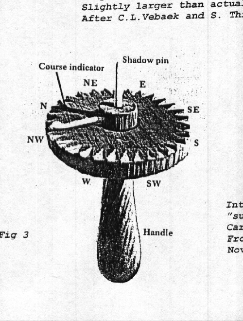
6) That a line drawn on the disk is always used as a north/south marker. Note: An imaginary line between the center post and a convenient notch would serve as well.
7) That a line drawn perpendicular to the N-S line represents true east and west. Note: This line does not need to pass through the center of the disk.
8) That the sunrise and sunset are always true east and west at equinox. That sunrise and sunset of the same day are always true east and west of each other.
9) That a line drawn between any convenient distance (the width of a hand, finger, knotted string, sun's diameter. . . ) of the sun above the horizon in morning and again the same height in the afternoon is also east and west. While this line is always perpendicular to the north/south line, the angular distance between sunrise and north changes each day.
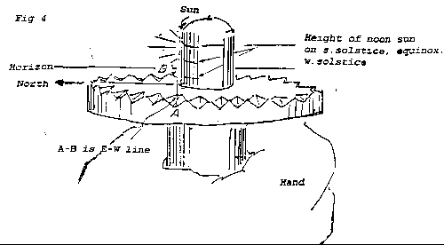
10) That the shadow of a gnomon is shortest at noon and points north. The shadow length varies with height of gnomon, which can be calibrated in various ways. One convenient scheme is to raise or lower the handle/post supporting the disk and use appropriate markings to denote dates (See Figs 4 and 5 or elevations of sun above horizon.
11) That fellow Norse navigators who had been to Gibraltar observed, while traveling south, that the north star is lower on the horizon with fewer stars visible between it and the horizon beneath it, and that the sun is higher at noon (it makes shorter noon shadow).
12) That the navigator must decide on and always use the same point for sunrise/sunset-- when the sun's full diameter is on the horizon, when the lower edge (limb)is on the horizon or on the first/last tip seen.
13) That the sun compass was used for gathering data to collaborate other signs which seamen know, such as wave patterns, prevailing winds, storm winds, seaweed/flotsam, shore birds, shoreline markers, size of bow wave, position of the north star or other stars, changing shadow of some convenient part of the ship, . . . .
14) That the disk was held horizontally. Various ways to maintain a horizontal disk during observation have been suggested. Each has some obvious objection to convenience or accuracy.
a) sighting across the disk and making it parallel to the horizon (Fig 4).
b) floating the disk in a tub of water
c) weighted handle, or a convenient pendulum device suspended below the disk. This assumes that a weight can be great enough to maintain a horizontal plate but not interfere with trusting the wrist or fingers as a gimbal.
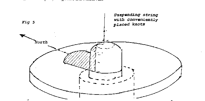
d ) suspended from a string. Knots on the string could substitute for a calibrated, gnomon. (See Fig.5) This method is author's choice for establishing noon and north. A pitching boat is not a stable platform; however, when the pivot point of a pendulum moves, the pendulum stays relatively stable.What the Norse may not have known, but which makes the "Sun Compass" work:
1) A concept of degrees or a latitude and longitude grid. They could have expressed angular distances in "sun diameters."
2) That the angular distance to the north star is the same as the degrees of latitude. (See Fig. 16.) That is, when the north star is maintained at same distance above the horizon, the direction of sailing is West or East.
3) That the gnomon's shadow at sunrise and sunset extends to infinity. The time-lag between sunup and when the sun is high enough for it's shadow to fall on the disk differs with latitude--being sooner near the equator where the sun's path is nearly vertical. This phenomenon would be an indication of latitude, if the Norse had some device to tell time accurately--up to three hours in high latitudes. Note: We can assume that at any home latitude, the gnomon height would be adjustable to accommodate for a convenient time lag. Thus, the height of the gnomon would be an indicator of latitude and could be calibrated accordingly.
5) From an observer at any latitude:
o At equinox, the sun rises true east. This is designated as 90 degrees from true north on the compass, and as zero degrees in OLD FARMER'S ALMANAC (to indicate angular tip of earth's axis from the plane of orbit).
o At equinox, the sun sets true west. On any other date, the sunrise and sunsets are true east and west of each other--not of observer. Note: The real path of the sun is a spiral, similar to the threads on a screw; therefore, sunrise and sunset readings are not exactly true east and west. Considering other sources of sun-compass error, the difference is insignificant for any one day. Significance begins after many days.
o The angle which the sun's path makes with the horizon is the same for any day on that latitude and it grows greater when approaching the equator. Determining North Is the Most Accurate Use of the Sun Compass
I) By Angular Distance Along the Side of the Disk.Note: We must assume that the navigator knew the angle sunrise makes with true north at home port, and that it becomes measurably smaller as the season progresses to summer solstice.
Note: At the same latitude, the angular distance from observer to sunrise or sunset and north changes every day; however, angular distances are the same on the same day each year. Note: Near solstices, the sun's rising and setting location show almost no change.
Procedure: Align the disk with the horizon, view sunrise or sunset across the center of the disk. Compare the angle of sunrise with that of home port. The north notch or line will point north.The procedure for one morning or afternoon reading becomes:
1) Sight across any convenient notch (not the disk center or diameter), rotate the disk so that the line of sight (or shadow of the edge of the post) is parallel to the E-W line. After compensating for the time-distance from sunrise (east) to noon (south) or sunset (west), the N-S line will point north. (See Fig 4.)2) Using "Reference" notches One of the notches through which morning observations are made is used as a "reference" notch for the afternoon readings and the afternoon notch is used as a reference notch for the next morning. When morning and afternoon readings are taken with the sun at the same height above the horizon, guessing the time between noon and sunrise/sunset is not necessary. (Fig 14--x-x') Note: 1) We can assume that the careful navigator would make three or four readings each morning and afternoon (using different and successive notches). He would also be aware of the changes of shadow on some convenient part of the ship. 2) The notches on the disk do not need to be precise--merely convenient. They can be used for counting as well as for sighting. 3) Many of the same readings are possible with the moon, which is visible during long, high-latitude twilights. (Moon rises and moon sets are, about half of the time, within one or two degrees of those of the sun, but they can vary by as much as 5 degrees. This change is not abrupt and careful navigators would be aware of the growing difference.)
Procedure: Align the disk with the horizon, rotate disk so that the N-S line is in the general direction of north (morning readings to the left, afternoon readings to the right); cover the morning sun with the post or note the shadow of the edge of the post; rotate the disk so that the eye or shadow, the notch for yesterday's similar afternoon reading, the edge of the post, and the edge of the sun make a straight line. The N-S line points true north. The new notch on the disk over which this line passes is the"reference" notch for the afternoon reading.
As the morning sun approaches its highest altitude, the observed angle between the sun's position and north becomes greater. Late morning and early afternoon readings will use the notches in the lower portions of the disk as markers. The navigator may use these readings to check other readings. Please note (Figure 2) that many notches point as much toward the edge of the post hole, as to the center of the disk. Note: While many notches appear to indicate tangents to the centerpost; hence, reinforce this text, they may be misinterpretations of the picture. For a clear picture of the Greenland "bearing dial," see Vebaek and Thirslund p.10.
While shortest-shadow readings from the post will indicate true north, the angular readings along the side of the disk, when compensated according to the formula below, indicate distance traveled to north or to south from home port. The changes in length of noon-shadows are also indicators of distance, but are much more difficult to calibrate.
Note: The daylight readings and directions can easily be verified or corrected when the north star is visible.
II) By using a Gnomon The shortest shadow of the day points north. Note:
(1) The sun's angle with the gnomon changes with time of day and is highest at noon. The direction to the noon sun is due south. The shadow cast by the noon sun will be the day's shortest and it will point to true north
(2) As one approaches the equator, the noon sun appears higher in the sky.Note: Although this noon reading is accurate, it is tedious. Since the sun does not appear to change from near noon to soon after noon, noon is difficult to determine. At best, the navigator could tell when noon had just passed, then could adjust for noon /north accordingly.
When the noon sun is likely to be obscured by clouds, a "second best" reading can be made by determining the distance of the morning sun above the horizon any time it can be seen.
The reason for the large diameter of the post is now apparent. It will eclipse the sun when the disk is held near the eye and it will protect the eye! However, the shadow from the edge of the gnomon is equally as effective and without risk.
Navigating By The Sun Compass Note: The difference between finding north and navigating is that when knowing any of the directions, the navigator may establish a direction for the keel. When navigating however, he knows where he is in relation to where he should be. A transatlantic crossing would encounter fickle winds and at least a day in the Gulf Stream. Under normal conditions, the Gulf Stream's four knot current could take sailors 150 miles north of their intended destination. (For more discussion on effects of the Gulf Stream, see addenda at end of discussion.)
We know that the Norse calculated distances by days travel. Assuming that they would average 140 statute miles in 24 hours, they could use the sun compass to provide an idea of position as well as direction. Note 1): A degree along a meridian (N-S) is about 70 statute miles (60 nautical miles); therefore, they would change their sun compass edge reading by two degrees (four sun diameters) a day when traveling north or south, IF the sun were to rise consistently in the same place at home port. At this point, the navigator would guess, using many indicators or conditions (size of bow wave, change in sun angles, favorable winds, . . .), if the ship had made average time and could estimate real/virtual time. He could then say that they were X days from home port or, Y days from destination, were the destination known. Note 2) Since, parallels are shorter than meridians (except at the equator), a day's E-W travel (along a parallel) covers more angular degrees than N-S travel. Undoubtedly, this fact and the effects of the Gulf Stream account, in part, for why maps and concepts about the earth's shape were distorted. Furthermore, many early maps were made using days traveled as bases for distances.
Of course, in exploration, the destination would not be known. However, all Norse exploration could be within a few days of land--within range of sea birds. When destination was known, shortcuts across open water were possible by using a sun compass. We have legends of the Vikings carrying and releasing ravens to find land. (Boorstin, p.217)
According to "Where the Sun Rises and Sets" page 58 of OLD FARMER'S ALMANAC (Fig 7), at Norse home latitudes (60 degrees north), the angle which sunrise and sunset make with true north will vary by 106 compass degrees in 183 days, growing smaller as season progresses toward summer solstice, then not moving much for the ten days around solstice..). Note that the angular distance at 60 N. Lat must change 106 (53 +53) in 183 days (See "Fig 7). Keeping in mind that the change is not significant for the week before and after solstice, the angular distance along the edge of the disk must decrease about 0.6 degree each day (about one sun diameter) from winter to summer solstice.To Compensate for Change in Angular Distance on the Side of the Disk From Sunrise or Sunset To True North
I ) Navigating East or West: By careful compensating, the navigator would always know what the angular distance between sunrise or sunset with north would be at home port. Thus, at sunrise and sunset, he can determine north on the parallel of home port, and when his traveling calculations are similar to those at home port, he will be traveling due east or west from it.
Sailing along a line of same latitude can be easily verified by noting the north star's distance above the horizon. It is always the same for a given latitude.
From the "Sunrise Chart" (Fig 7), assume departure from 60 N. Lat. On May 10. The angle to sunrise above equinox is 37 above equinox direction (0 ). Ten days later, the angle to sunrise has changed by 6 to 43 -- about 0.6 degree each day (one sun diameter)..
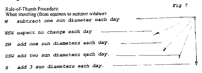
Rule-Of- Thumb Procedure in Northern Hemisphere: while navigating E or W (or sitting still at home port), compensate for sun's journey by subtracting from the sunrise reading on the disk edge, the equivalent of one sun diameter each day from winter solstice to summer solstice, and adding a similar amount for each day between summer solstice and winter solstice. (Make allowances for minimal sun-rise movement near equinoxes.) Note: Many assumptions about the "bearing dial" include a "course indicator" (See Fig.3) attached to a rotatable centerpost. Such a pointer would be handy for "remembering" the angular sunrise settings on the edge of the disk, but would interfere with other readings and would almost certainly have become moved sometime during the day. Since the disks were easily made, perhaps new miniature notches were carved for each day's travel. The Greenland Dial has many scratches on both sides.II) Navigating for Directions other than East and West
Assuming that a Viking ship would travel 140 miles in 24 hours; that is, two degrees along a meridian), it could go from 60 N. Lat. To 50 N. Lat. in five days.
According to the "Sunrise and Sunset" chart (Fig. 7), changing latitude by ten degrees south each 30 days, keeps the sunrise in same place as when the voyage started. Thus when traveling south, the navigator races the sunrise. At the chart, assume departure from 60 N. Lat. on May 10. The angle to sunrise is 37 above equinox reading (0 ). On may 15 the angle is 40 a change of 3 ( 0.6 each day--one sun diameter). At 50 N Lat. 5 days later (May 15), the sunrise is 30 above equinox reading, This represents a change on the edge of the disk of - 7 (about 1.5 degrees per day --3 sun diameters). Considering other chances for error, when traveling due south, subtract from angle of sunrise above equinox, three sun diameters each day. While traveling four diameters south, the sun is moving one diameter the other way (4-1 =3). While traveling SW, two sun diameters minus one equals one. Always reset when north star is visible. Rule-of-Thumb Procedure: When traveling (from equinox to summer solstice):
W subtract one sun diameter each day
WSW subtract one sun diameter each two days.
SW expect no angular change each day.
SSW add two sun diameter each two days.
S add 3 sun diameters each day.
While traveling west, reset the compass with the north star. It should remain the same height above the horizon.
While traveling south, reset the compass with the north star. It should have become further above the horizon by four sun diameters each day ( 10 in five days).
While traveling SW, reset the compass with the north star. It should become further above the horizon by two sun diameters each day.To Determine Ship's Location Between Home Port and Known Destination by the Paths of Gnomon Shadows
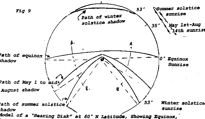
Paths of the gnomon's shadows when plotted on the disk for equinox and solstice dates follow hyperbolic curves which are specific and constant for a given height of gnomon and a given latitude. (See Fig. 10). Compensation for change in date are noted in changes of sunrise or sunset directions and by length of noon shadows. Appropriate hyperbolic lines for date changes can be drawn or "visualized" between permanently marked lines of solstices and equinoxes.
The noon shadows are not evenly spaced. With a fixed height of gnomon, summer solstice and equinox noon shadows are much closer together than are winter solstice and equinox shadows. This fact is important in interpreting some of the scratches on the Greenland Disk. (See Figs. & )
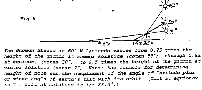
The Gnomon Shadow at 60 N. Latitude varies from 0.75 times the height of the gnomon at summer solstice (cotan 53 ), through 1.9x at equinox, (cotan 30 ), to 9.5 times the height of the gnomon at winter solstice (cotan 6 ).
Lines AB and A'B' represent the gnomon's shadow for days between solstices when the sun is a predetermined height above the horizon. This provides a further check on position and the only semblance of a concept of longitude without knowing the latitude-longitude grid we use today or using dead reconing.
Because a route can be planned/plotted ahead (by using the above formula), the sun compass will provide a surprisingly clear concept of position in relation to known destination and home port. At the right place, at that predetermined time of day, on a given number of days sailing from solstice or to equinox, the shadow should be at a certain point. As the navigator compares where he is to where he should be, he can compensate for errors in dead reckoning, drift, or set. Note 1): Most sea voyages were less than thirty days. Note 2): The same inferences can be drawn from the noon shadows. However, since the noon lines are close together, those nearer the edge of the disk provide more accurate readings. (However, see Figs. & )
Note: As one approaches the north pole, the winter solstice and equinox shadows disappear and the sun makes a circle in the sky, rising to 23.5 above the horizon at summer soldstice.. After summer solstice it circles the sky to set at autumnal eqinox.
Considerations on the Scratches:
The importance of some of the scratches become apparent with the above considerations. Answering for the other scratches must be obtuse. Undoubtedly, the navigator had enviable status. We therefore cannot dismiss the fact that while some scratches were important navigational readings, others may have been record-keeping, and some can represent a compromise between reality and what the navigator wanted reality to see. Other scratches could well have been flim-flam. They were placed to confuse ursurpers. We know that rune writing enjoyed an aura of magic and status--why not navigating?
In general, the E-W scratches are reference scratches to orient the disk. All other scratches and angles of interception on edges of the disk were made in reference to them.
The Scratches which are tangent or parallel to tangent to the post edge are multiple sun readings.
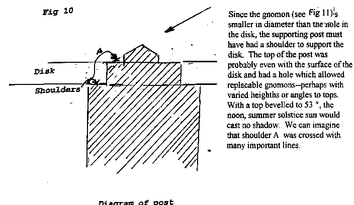
Since the gnomon (see fig xx) is smaller in diameter than the hole in the disk, the supporting post must have had a shoulder to support the disk. The top of the post was probably even with the surface of the disk and had a hole which allowed replacable gnomons--perhaps with varied heighths or angles to tops. With a top bevelled to 53 , the noon, summer solstice sun would cast no shadow. We can imagine that shoulder A was crossed with many important lines.
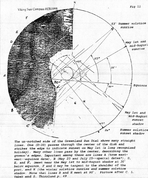
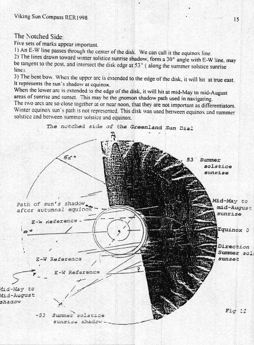
The Notched Side:
Five sets of marks appear important.
1) An E-W line passes through the center of the disk. We can call it the equinox line.
2) The lines drawn toward winter solstice sunrise shadow, form a 30 angle with E-W line, may be tangent to the post, and intersect the disk edge at 53 ( along the summer solstice sunrise line).
3) The bent bow. When the upper arc is extended to the edge of the disk, it will hit at true east. It represents the sun's shadow at equinox. When the lower arc is extended to the edge of the disk, it will hit at mid-May to mid-August areas of sunrise and sunset. This may be the gnomon shadow path used in navigating. The two arcs are so close together at or near noon, that they are not important as differentiators. Winter equinox sun's path is not represented. This disk was used between equinox and summer solstice and between summer solstice and equinox.4) A slightly inclined line above the bow. When the line is interpreted as being part of a concave hyperbole, it is the winter solstice shadow of a short gnomon.
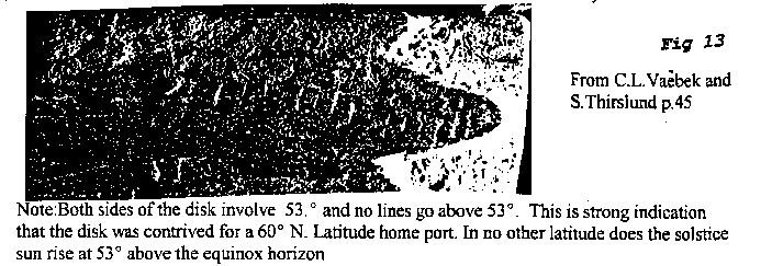
5) A series of short rather evenly spaced lines on the "north pointer" notch. These could a) Keep track of repeating events--days, or b) when used with a gnomon of appropriate height, as a noon marker to determine position. When using the lower mark to represent the three or four days before and after summer solstice, each mark above will represent one day.From C.L.Vaebek and S.Thirslund p.45
Note:Both sides of the disk involve 53. and no lines go above 53 . This is strong indication that the disk was contrived for a 60 N. Latitude home port. In no other latitude does the solstice sun rise at 53 above the equinox horizon
****
Addenda
The Gulf Stream Since sea legends of giant whirlpools abounded for centuries, the Gulf Stream would have tested the Viking sailor's courage and faith in his "bearing dial." While the navigator would have been familiar with currents, he could have no experience with concepts of a huge "river" in the ocean. When encountering the Gulf Stream while travelling north or south, the outcome position would have been much different than dead reconing could account for. When entering the Gulf Stream going east or west, the man at the rudder would realize a difference in effort to maintain a steady course. The stream is two hundred miles wide in some latitudes and it increases in speed as one approaches midstream. The fabled sea whirlpool would act the same. Only the brave or foolhardy would enter a maelstrom in an open boat.
Some mathematics
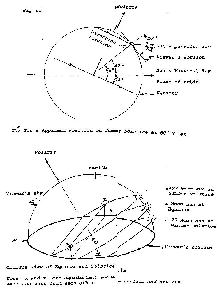
The sun's rays which strike the earth are parallel to each other. The equinox sun rises true east and sets true west for all observers of all latitudes. Geometrically, the vertical ray would pass through the center of the earth and is purpendicular to the equatorial horizon all day. At equinox, the sun is directly overhead at the equator. For all other northern latitudes and dates, the noon equinox sun appears above the southern horizon as the complementary angle of the latitude minus the angle which earth's axis makes with the plane of its orbit. (At 60 deg N. Latitude, the equinox (angle zero) noon sun is 30 above the horizon). Note: The parallel rays are cut by the transversal of the earth's radis, that makes the corresponding angles of parallel lines equal. The viewer's horizon is tangent to the circle at his position. It is purpendicular to the earth's radius at the point of tangency--making two angles, one is equal to the degrees of latitude, the other is it's complement. Because the earth turns into the sunrise, this angle is the angle of the noon sun above the southern horizon.The length of the gnomon shadow at noon of any one day is the height of the gnomon times the cotangent of noon sun's angle with the horizon. All points of any day's gnomon shadow fall on a hyperbolic curve between sunrise and noon and noon and sunset. (See Fig.)
To carve a sun compass
The pointer between the first two notches on the disk is the north indicator. It will point from the center of the disk. The pointers between the 2nd-3rd, and 4th-5th notches carved will be 90 degrees from this. They also point from the center of the disk. They indicate true east and west--the equinox sunrise and sunset. The remainder of the notches indicate tangents to the center- post. On land, the navigator can always check his north orientation with the north star or the noon shadow. He can determine the angle that sunrise makes with north--this is his "reference" angle/notch for the afternoon reading. By using this angle as his starting point, and computing change because of date, he will always know north direction at sea. To calculate distance (hence position from port--home or destination) or distance from route after extended cloudiness or a storm, requires compensating for his date-distance from equinox or solstice and establishing appropriate changes in angle (using the formula above) between sunrise or sunset and north. His secondary procedure would be to 1) predict and trace the path of the gnomon shadow at equinox. 2) trace the path on his present date (on land) 3) predict the change in shadow- path accordingly.
Conclusions
The sun compass is accurate only at noon, when the tip of the gnomon shadow is shortest, it then points north.All other readings depend on reference to previous reading or comparison with home port or destination. Since errors compound on each other, the longer at sea, the more inaccurate the compass becomes as an item for navigation..
All readings depend upon a horizontal disk.
The line from sunrise to sunset on any day is east and west. North can be interpreted from this line.
Direction of travel and location are some factor added to or subtracted from the previous reading. Such factors include number of days to or from equinox, to or from solstice, days of travel, angular change in sunrise, sunset, and noon, and supposed distance covered. Note: accuracy increases when days toward equinox and past solstice are both considered. For instance, forty days past solstice and fifty days before equinox.
Each sun compass was probably specific to its home port and to its owner. While many disks might have been similar, the center posts were probably different. In order to be reliable, each compass should have been used at home port for at least a year where marks denoting the gnomon's shadow at solstices and equinox could be etched. Further speculation includes that a home-port sun compass was maintained at each city and that permanent sun compasses were established at destination locations. These would be useful in resetting each sun compass. Note:
1) To establish the angle, north must be established (by north star or by calculations described above) and without moving the compass, sunrise direction must also be established. This cannot be ccomplished on a ship since north, sunrise, and sunset cannot be determined at the same time.
2) This may account, in part, for the many solar based stone calendar sites in North America and provide an idea regarding the extent of Norse presence. We must assume that after the existence of "Vinland the Good" was known, many voyages from many Norse cities were launched within the 300 years of the eleventh through thirteenth centuries--to think otherwise would be unrealistic. Incidentally, one calendar site at Solon, Maine (near the 45 parallel) indicates both true and magnetic north. Could it mark a transition time when some master of the sun compass was experimenting with that "new- fangled contraption"--the magnetic compass? An interesting foot-note to the Solon site--the magnetic line is shorter than the true north line!The sun compass is valuable when added to other factors which seamen knew--wave patterns, shorelines configurations, shore birds' habits, prevailing/storm winds, bow waves, change from shadow of some convenient part ofthe ship, . . . .. When compared to modern navigation, the sun compass, used alone, was much more reliable than panic; however, when Norse navigators missed long voyage destinations by a few days, Norse seamen probably considered the feat well done.
Undoubtedly, the Norse seamen revered and bragged about their favorite navigators like we do about our favorite baseball pitchers.
Sources
Daniel J Boorstin, "The Discoverers," Random House, New York, 1983 Gwyn Jones, "A History of The Vikings," Oxford University Press, 1973 Howard LaFay, The Vikings," Special Publications Division , National Geographic Society, Washington DC, 1972 Magnus Magnussen, "Vikings!" E.P.Dutton, New York, 1980 Robert B. Thomas, "The Old Farmer's Almanac," Dublin, NH, 1998 Tre Trychare, "The Viking," International Book Society (A Division of Time- Life Books), 1947.
I wnat to add C.L.Vaebek and S.Thirslund, "Viking Sun Compass " to this list. My son has the book now. This book is not clear on identity of the publisher.WHERE THE SUN RISES AND SETS
OLD FARMER'S ALMANAC 1998
By using the table below and a compass, you can determine accurately where on the horizon the Sun will rise or set on a given day. The top half of the table is for those days of the year, between the vernal and autumnal equinoxes, when the Sun rises north of east and sets north of west March 21 through June 21 are listed in the left colurnn, June 21 through September 22 appear in the nght column. Similarly arranged, the bottom half of the table shows the other half of the year, when the Sun rises south of east and sets south of west. Here's how it works. Say you live in Gary, Indiana and need to know where the Sun will rise or set on October 10. Use the time Correction Tables (pages 214-218) to determine the latitude of your city or the listed city nearest to you. Gary is at 41° latitude. Find the 40' latitude column and you see that on October 10 the Sun rises 8° south of east and sets 8° south of west. Of course, you can determine figures for other latitudes and days not actually shown in the table by using extrapolation.
Latitude      0°          10°       20°         30°      40°       50°       60°    Latitude

Date                                                                                Date

Mar. 21       0°           0°        0°         0°       0°        0°         0°    Sept 22
Mar.31        4° N         4° N      4° N       4° N     5° N     6° N      8° N    Sept 14
Apr. 10       8° N         8° N      8° N       9° N    10° N    12° N     15° N    Sept. 4
Apr. 20      11° N        12° N     12° N      13° N    15° N    18° N     23° N    Aug. 24
May 1        15° N        16° N     16° N      17° N    20° N    23° N     31° N    Aug. 14
Mav 10       17° N        18° N     19° N      20° N    23° N    28° N     37° N    Aug. 4
May20        20° N        21° N     21° N      23° N    26° N    32° N     43° N    July 25
June 1       22° N        22° N     23° N      26° N    29° N    36° N     48° N    July 13
June 10      23° N        24° N     24° N      27° N    31° N    37° N     51° N    July 4
June 21    23.5° N        25° N     25° N      27° N    31° N    38° N     53° N    June 21

Sept. 22      0°           0°        0°         0°       0°       0°        0°      Mar. 21
Oct. 1        3° S         3° S      3° S       3° S     4° S     5° S      6° S    Mar. 14
Oct. 10       6° S         7° S      7° S       7° S     8° S    10° S     13° S    Mar.5
Oct. 20      10° S        11° S     11° S      12° S    13° S    16° S     20° S    Feb. 23
Nov.1        15° S        15° S     15° S      16° S    18° S    22° S     29° S    Feb.12
Nov. 10      17° S        18° S     18° S      20° S    22° S    27° S     36° S    Feb. 2
Nov. 20      20° S        21° S     21° S      23° S    26° S    31° S     42° S    Jan. 23
Dec. 1       22° S        23° S     23° S      25° S    29° S    35° S     48° S    Jan. 13
Dec. 10      23° S        24° S     24° S      27° S    30° S    37° S     51° S    Jan. 4
Dec. 21      23.5° S      25° S     25° S      27° S    31° S    38° S     53° S    Dec. 21
bron: de site http://www.sjolander.com